Raniganj Fm
Type Locality and Naming
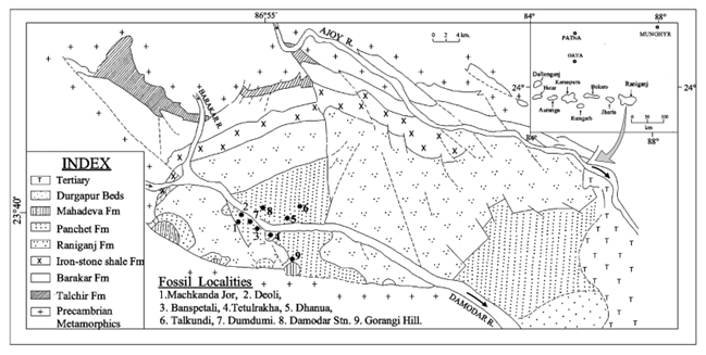
Damodar-Koel Valley: Blanford (1861) named the upper coal-bearing units of the Damuda Group of the Raniganj Coalfield as the Raniganj 'stage' after the type locality, designated as Raniganj Formation (Sastry et al., 1977). Raniganj town, Burdwan district, West Bengal is the type area of this formation. Damodar River and Nunia nala, a tributary of Damodar river, represent the best exposed sections of the formation. [Original Publication: Blanford, W.T. 1861.- On the geological structure and relations of the Raniganj coalfield, Benga. Mem. Geol. Surv. Ind., 3(1), 1-196; ; Sastry, M.V.A., Acharyya, S.K., Shah, S.C., Satsangi, P.P., Ghosh, S.C., Raha, P.K., Singh, G., Ghosh, R.N. (Eds.), 1977 Stratigraphic Lexicon of Gondwana Formations of India, Misc. Publ,. Geol. Surv. India, vol. 36, pp. 170.]
[Figure 1: Geological map of Raniganj Coalfield, West Bengal with different Damodar valley coalfields (inset) (adapted from Tripathi & Satsangi, 1963; Abir Gupta, 2009)]
Lithology and Thickness
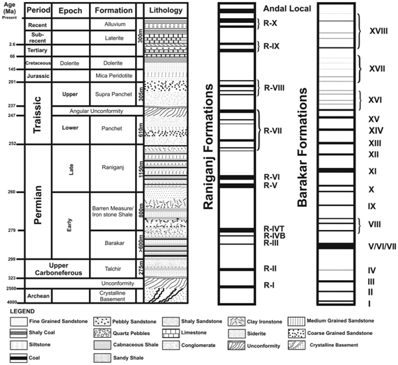
Sandstone with Coal. It consists of massive, cross-bedded to laminated fine- to medium grained calcareous sandstone interbedded with micaceous siltstone, shale and coal seams. Conglomeratic bands varying in thickness from 10 to 30 cm occur at places. The sandstones are generally greenish grey in color as seen in North Karanpura Coalfield (Raja Rao, 1987; Peter, 2009). Thickness varies from about 1130 m in type section; 800 m in Jharia Coalfield and 600 m in East Bokaro Coalfield (Sastry et al., 1977).
"The Late Permian Raniganj Formation of the Raniganj Basin within the Damodar Valley Basin belt contains a number of coal seams (14–20) but in other basins, the Raniganj Formation or its equivalents exhibit mainly thin and impersistent coal seams. On the other hand, the Glossopteris flora had their acme in development during the deposition of the Raniganj and equivalent formations." (Acharyya, 2019, Tectonic Setting and Gondwana Basin Architecture in the Indian Shield)
[Figure 2: Generalized lithostratigraphic succession of Damodar Valley with the sequence of coal seams in Barakar and Raniganj formations (after Raja Rao, 1983; Veevers & Tewari, 1995; Chattaraj,et al., 2019). Columns showing Raniganj Fm and Barakar Fm coal seams can be removed while making final maps)]
Relationships and Distribution
Lower contact
Raniganj Formation in the type area conformably overlies Barren Measures Fm (=Ironstone Shale) whereas in Bokaro Coalfield, beds overlap the Barren Measures Fm and come in direct contact with the Barakar Fm with a slight unconformity. It is differentiated from the underlying Ironstone Shale by occurrence of coal seam and arenaceous lithology.
Upper contact
Raniganj Formation is conformably overlain by the Panchet Fm, which is devoid of coal or carbonaceous shales.
Regional extent
Raniganj Formation is correlated with the Bijori Fm of Satpura region, with the Lower Pali member of the Pali Fm of Son basin, and with Kamthi Fm in the Pranhita-Godavari belt. [For temporary GeoJSON, put as all Gondwana Basin, similar to the underlying Barren Measures above the Barakar Fm (also coal-rich).
.
GeoJSON
Fossils
Invertebrates: Bivalves - Sanguinolites, Carbonicola, Palaeomutela, Anthraconauta (Chandra, 1996); Vertebrates: Fish - Amblypteris sp. (Mukherjee and Ghose, 1973); Estherid: Monoleaia sp., Cyzicus and Lealid (Ghosh et al. 1988); Ichnofossils: Skolithos, Arenicolites, Cylindrichnus, Rizocorallium, Teichichnus, Thalassinoides, Scolicia, Planolites, Limgulichnus, Copophinoides, Diplocraterion, Macaronichnus, Plaeophycus, Curvolithos (Mukhopadhyay, 1996);
Flora: Glossopteris and Vertebraria are the most dominant constituent; Glossopteris conspicua, Palaeovittaria, Belmenopteris, Glossopteridales, Kendostrobus, Dictyopteridium, Plumsteadiostrobus, Jambadostrobus, Venusostrobus, Senotheca, Rhabdotaenia, Pterophyllum, Searsolia, Damudaoxylon, Trigonomyelon, Megaporoxylon, Araucarioxylon, Schizoneura gondwanensis, Phyllotheca indica, Raniganjia, Trizygia speciosa, Neomariopteris, Dichotomopteris, Dizengotheca, Sagittophyllum harrisii, S. pantii, S. sagitatum, S. cordatosagittatum, S. major, S. auriculatum, S. elongatum, Laceyphyllum, calcaratum (Bose et al. 1989; Chauhan, 2004); Palynofossils: Striatopodocarpites, Faunipollenites, Crescentipollenites, Striates, Lahrites, Verticipollenites, Densipollenites, Microfoveolatispora, Microbaculispora, Cyclogranisporites, Horriditriletes, Gnetacepollenites and Vittatina. Frequency of trilete spores, Microfoveolatispora, Microbaculispora, Cyclogranisporites and Horriditriletes is more in the middle part of the Raniganj Formation (Tiwari and Tripathi, 1988; Meena, 1998). The assemblage corresponds to Palynoevent-V (Tiwari, 1996).
Age
Depositional setting
Sen et al. (2016) analyses of sedimentary facies, architectural elements and geophysical well logs from core show following dominant facies in the Raniganj Formation - Sandstone dominated facies, Sandstone - shale heterolith facies, Shale facies and Coal facies. According to them, the Lower part of Raniganj Formation is channel dominated which corresponds to thick amalgamated sand bodies while the Upper part represent overbank deposits that show predominance of channel avulsion. Sedimentary architectural elements identified are – fluvial channels, back swamp - flood plain, levee and crevasse splays. Overall Raniganj Formation can be divided in five depositional sequences, each comprising of two general depositional facies assemblages: channel dominated facies and floodplain dominated facies, which are interpreted as low- and high-accommodation system tracts respectively (Sen et al., 2016).
A marine incursion is evident by the presence of marine bivalves in association with brackish-freshwater bivalves. The presence of fossil Skolithos etc. also indicates marine incursion (source Peter, 2009). Based on integrated study of cores, outcrops and geophysical data, Sen et al (2016) suggested a meandering fluvial environment for the Raniganj Formation.
Additional Information
References
Blanford (1861); Bose et al. 1989; Chandra, 1996; Chauhan, 2004; Ghosh et al. 1988; Meena, 1998; Mukherjee and Ghose, 1973; Mukhopadhyay, 1996; Peter, J. 2009; Raja Rao, 1987;
Sastry et al., 1977; Sen, S., Das, N., Maiti, D. 2016. Facies Analysis and Depositional Model of Late Permian Raniganj Formation: Study from Raniganj Coal Bed Methane Block. Journal Geological Society of India, 88, 503-516.; Tiwari, 1996; Tiwari and Tripathi, 1988
Chattaraj, S., Debadutta Mohanty, Tarkeshwar Kumar, Gopinath Halder, Kanhaiya Mishra. Comparative study on sorption characteristics of coal seams from Barakar and Raniganj formations of Damodar Valley Basin, India. International Journal of Coal Geology 212 https://doi.org/10.1016/j.coal.2019.05.009

